|
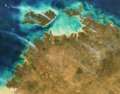
Pictures (raster images) of the earth's surface captured from satellites orbiting the earth are a vital tool for mapping and monitoring fires. The image below,
from the MODIS satellite, shows smoke coming from many fires in the Top End of the NT in July 2015.
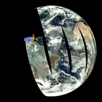
These Earth Resource satellites are specifically designed to measure aspects of the earth's surface using on-board 'sensors' (cameras). These satellites
orbit/circle the Earth in a known and consistent way so they pass over the same spot on the earth's surface at regular intervals.
There are many Earth resource satellites, each with different sensor and orbit characteristics. It is important when using information derived from these satellites
to understand the type of information each provides and how it can be used. The satellites cannot always 'see' fires, so understanding their limitations is key to
their effective use.
We'll focus on the two satellites most commonly used in fire mapping and monitoring across northern Australia. They are the Landsat and MODIS
earth resource satellites.
1. Key Terms
Key to understanding satellite data are their spatial and temporal characteristics.
Spatial (space) in the context of satellite data refers to the size of the image. This is described in terms of resolution and extent.
- Spatial resolution refers to the on-ground size of a pixel in a satellite image.
- Spatial extent refers to the on-ground width of a satellite image overpass.
Temporal (time) refers to how long a satellite has been capturing imagery (extent) and how frequently it captures imagery (resolution). The temporal frequency
is also referred to as the revisit frequency.
Spatial Resolution
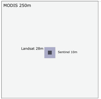
The graphic above shows the on-ground resolution or pixel size of three earth resource satellites (1) MODIS with each pixel 250x250 metres, (2) Landsat 28x28
metres and (3) the Sentinel 2 satellite with a 10 x 10 metre resolution.
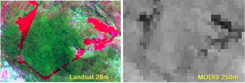
The on-ground resolution has significant implications for a satellite's ability to accurately map on-ground fire activity.
For example, the graphic below shows an aerial incendiary run near Nitmiluk National Park from the 10th May 2015. On the 28m Landsat image (left) the incendiary line
very clearly appears in red. Importantly what is also clear is where there are holes/breaks in the burn line that fires could creep through. None of this is clear on
the 250m resolution MODIS imagery.
It is clear from the example above that Landsat imagery provides the most detail for mapping burnt areas from satellite, however there are two primary limiting
factors for using Landsat imagery for daily fire monitoring. This first is due to its relatively small spatial extent, and secondly it's low temporal resolution.
Spatial Extent
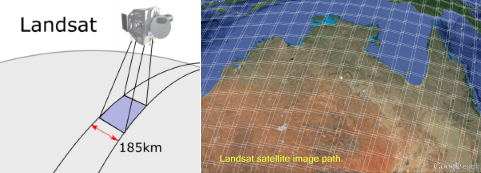
Every Landsat orbit (overpass) captures imagery along a 185km-wide path. This means that to capture satellite pictures for all of north Australia, as shown above,
many orbits and hundreds of images would be required
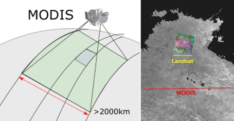
In contrast a MODIS satellite overpass captures imagery over a 2000km-wide path. This means that, as shown above, MODIS can map all of northern Australia in two
overpasses or images.
Temporal Resolution (Revisit Frequency)
he other key factor is revisit frequency, or the amount of time between when a satellite captures an image. With MODIS, because the spatial extent is greater, it
requires fewer orbits of the earth, thus it's overpass return frequency is higher. This higher temporal resolution means that the MODIS satellite will pass over the
same place every day whilst Landsat takes 16 days before revisiting the same location.
Furthermore, the MODIS sensor (camera) is actually on board two satellite platforms, one named Aqua and one named Terra. This results in a MODIS sensor imaging the
same place on the earth's surface up to twice a day. This very high temporal resolution is critical for mapping, monitoring active fires and responding quickly to
emergency situations.
Due to these attributes MODIS satellites are currently the basis for most global and continental scale fire mapping. As well as providing the data for mapping burnt
areas, they also provide hotspot data depicting active fires.
In addition to MODIS, there are a number of other satellite sensors that contribute to collecting hotspot data. This reduces the amount of time for the collection
of hotspot data down to a few hours. However, the accuracy of hotspot locations varies between satellites.
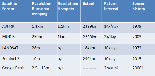
The table below summaries the major characteristics of the main earth resource satellites used in fire management.
2. Which Satellite to use for what?
There are a range of satellites used in fire management. Surprisingly, all the data commonly used is provided freely by the satellite operators, which in most
cases is the U.S. government (NASA), and is available on line to download.
AVHRR This satellite sensor has been around for more than 35 years. So, whilst its spatial resolution is very low, the fact that it has imagery going back over
many decades is very useful for developing background information about the histories of fires in a landscape. Using this satellite we can compare fires now to what
they looked like many years ago and see if there have been any changes.
MODIS The MODIS satellites provide much higher spatial resolution data than the AVHRR sensors and have been used for the last 12 years for both mapping fires across
northern Australia and providing hotspot information. However these satellites are getting old and may need replacing soon. The most likely contender for replacing MODIS
is the VIIRS (Visible Infrared Imaging Radiometer suite) sensor which has a similar spatial resolution
LANDSAT Landsat is a series of Satellites that have been operational for over 40 years providing the most comprehensive historic data set of the earth's surface.
The current Landsat satellite is called Landsat 8. Landsat is easy to access and provides a relatively simple way to see and/or map burnt areas in high resolution. As we
saw earlier, Landsat can be very useful to access the outcome of your aerial incendiary burns.
Sentinel-2 Is a very new satellite launched recently by the European Space Agency (ESA). Sentinel 2 data should become freely accessible some time in 2016. It's
high spatial and temporal resolution will make it a great extra tool for high resolution burnt area mapping.
Google Earth Provides satellite imagery from a number of sensors. Due to the high resolution of google earth imagery it is often used as a tool to visualise
landscapes and infrastructure. It is also often used as a base for overlaying other spatial data such as hotspots or burnt area mapping. However it ios updated very
infrequently and will not show current conditions. You must alos remember that hotspot data only shows the approximate location of a fire and may be hundreds of metres
out, so comparing this data to high resolution Google Earth imagery can be deceiving.
3. Will satellite images get better in the future?
The number and type of earth resource satellites available for use by fire managers is constantly changing as old satellites die and new ones are launched. However
there will usually be a trade-off between the spatial resolution, spatial extent and the revisit frequency. Some satellites will be designed to capture high resolution
data and each image will usually cover a small area - and will be updated infrequently. Other satellites will produce 'continental scale' images that are updated
frequently but at a lower spatial resolution. Some satellites might be slightly better than others however they will still fall into these two 'regional' and
'continental' scale categories.
In the case of the regional/local scale satellites, the Sentinel 2 sensor promises to increase both the spatial and revisit (temporal) resolution, enhancing Landsat-scale
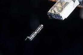
applications. New micro-satellites that are being placed in orbit dozens at a time (shown below) promise to bring high spatial and temporal resolution. These satellites
may be able to deliver sub 10m resolution images for a given location that area updated daily. But such services may be expensive and will involve examining many images
to cover a large area.
On the other hand the demise of the MODIS satellites could see a slight decrease in the spatial and revisit (temporal) resolution fire data at this larger scale.
|